Three projects on GNSS-free navigation using Phased-array Radio System
See this post on the NTNU TekNat blog for more context.
Background
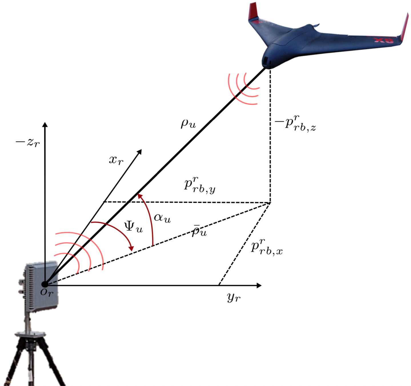
Today, Global Navigation Satellite System (GNSS) is used in a myriad of navigation applications, such as drones, but also manned aircraft. The last years have also shown an increase in jamming/spoofing of GNSS signals, with the ultimate consequence of loss of vehicle and personnel. Examples include the Iran-U.S. RQ-170 incident where Iranian forces sucessfully captuered a U.S. drone, spoofing near Russian military bases and jammers causing problems for Norsk luftambulanse. Before unmanned aerial vehicles can be used for safety critical applications, this vulnerability must be addressed. One way avoid the GNSS vulnerabilities is to rely on position measurements from another source, such as a Phased Array Radio System (PARS). A PARS base antenna consists of multiple small antennas that are positioned in a two-dimensional array. Through timing and estimation of the antenna characteristics, an estimate of the spherical position (elevation angle, azimuth angle and range) of the vehicle can be found, illustrated below.

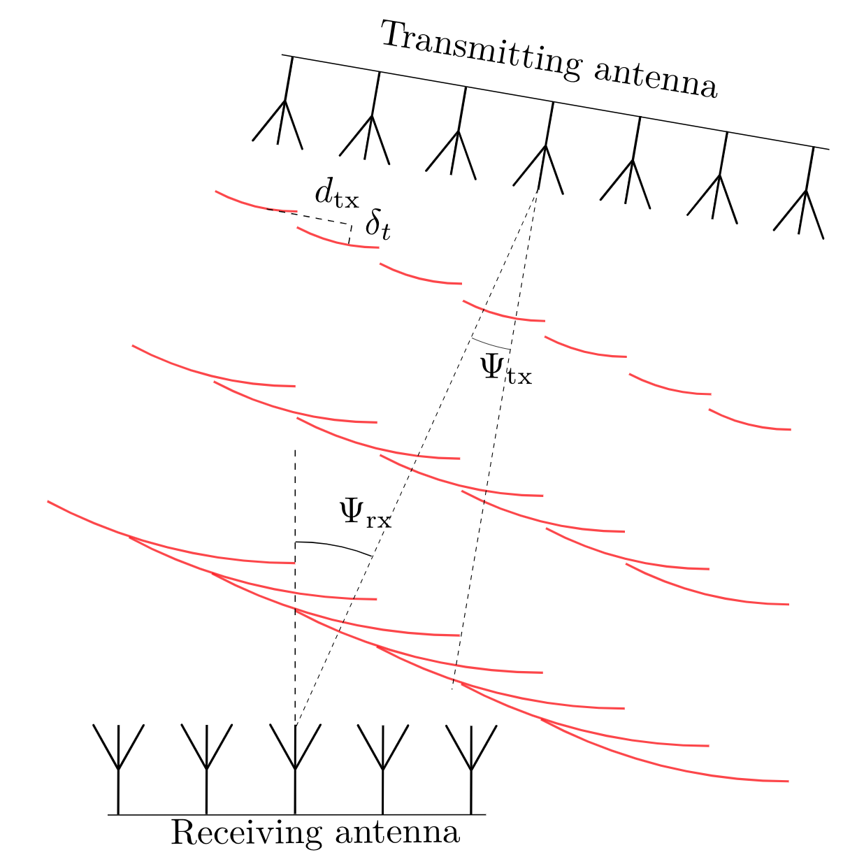
The figure below illustrates how the differences in the phase of the received signals at the different antenna locations can be used to determine the direction of the incoming signal, in one dimension. This leads to an electronically steerable highly directional antenna system. Unlike conventional mechanically steerable directional antennas, the PARS system is small, powerful and agile, and can send and receive in multiple directions at the same time in order to serve multiple moving nodes. The inherent beam-forming in the PARS can be used to locate the radio nodes onboard UAVs with a high accuracy. 
Presently, a navigation solution capable of providing position, velocity and attitude estimates that is used by a UAV in closed loop flight, has been developed. Here estimated azimuth angle, elevation angle and range from a “black-box” Phased-array radio system is used to aid inertial navigation.
Scope project 2: Direction-of-Arrival estimation for PARS
The goal of this project is to investigate current state-of-the-art algorithms for estimating the elevation angle, azimuth angle and range, known as direction-of-arrival estimation. It is of particular interest to investigate how these algorithms can be extended to use knowledge of the motion of the UAV, from e.g. an onboard accelerometer.
Proposed tasks, project 2
- Investigate existing algorithms for Direction-of-Arrival (DoA) estimation
- Comparison of a selection of these algorithms in simulations small simulations
- Demonstrate the effectiveness of the algorithm on existing data from flight experiments.
- Conclude the work in a written report
This work can be extended into a master thesis, focusing on integrating the DoA estimates with other sensors in e.g. a Kalman filter.
Prerequisites
This is a list of recommended prerequisites, more to signal what it will involve than to be used as a filter on candidates.
- Project 1: Strong theoretical background and interest in statistics for estimation/sensor fusion, through e.g. TTK4250 Sensor Fusion (which also could be taken in parallel with the project, instead of the two 3.75 credit specialization courses).
- Project 2: Strong theoretical background in signal processing, such as TTT4120 - Digital Signal Processing
- Project 3: Hardware know-how, Kalman filter
Contact
Contact supervisor Kristoffer Gryte for more information.
References
For 1: Blackman, S. S. Multiple hypothesis tracking for multiple target tracking. AES 2004. For 2: Schmidt, R. Multiple emitter location and signal parameter estimation, 1986
Groves, P. D. 2013. Principles of GNSS, Inertial, and Multisensor Integrated Navigation Systems. Artech House.
Gryte, Kristoffer, Torleiv Håland Bryne, and Tor Arne Johansen. 2021. “Unmanned Aircraft Flight Control Aided by Phased-Array Radio Navigation.” Journal of Field Robotics.
Gryte, Kristoffer, Torleiv H. Bryne, Sigurd M. Albrektsen, and Tor A. Johansen. 2019. “Field Test Results of GNSS-Denied Inertial Navigation Aided by Phased-Array Radio Systems for UAVs.” In 2019 International Conference on Unmanned Aircraft Systems (ICUAS), 1398–1406. https://doi.org/10.1109/ICUAS.2019.8798057.
Gustafsson, Fredrik. 2012. Statistical Sensor Fusion. 2nd ed. Studentlitteratur.
Niedfeldt, P. C., and R. W. Beard. 2014. “Multiple Target Tracking Using Recursive RANSAC.” In 2014 American Control Conference, 3393–8. https://doi.org/10.1109/ACC.2014.6859273.

